
The Sinking of the Edmund Fitzgerald
The sinking of the Fitz closed the age when human judgment alone had to contend with Great Lakes. Now human intelligence is amplified by machines.

.jpg)
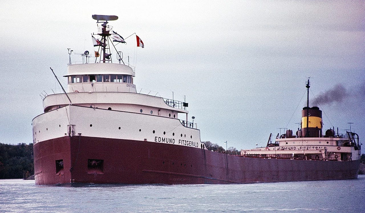
Fifty years ago today, the SS Edmund Fitzgerald sank. For any child of the Great Lakes growing up in the 1990s, as I did, the event is infamous; not only because Gordon Lightfoot’s song was constantly played on soft rock stations. The sinking of the ship was a marker between the Midwest as a Factory Belt and the Midwest as a Rust Belt. Hauling ore from the Iron Range in Minnesota to iron works in Michigan, those famous last lines from Captain McSorley captured perfectly the Midwestern reserve in the face of adversity: “We are holding our own.”
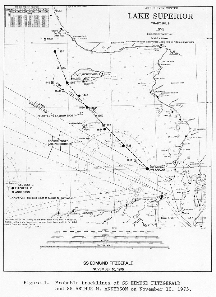
Having spent a lifetime reading about the shipwreck, I now see the event as a true tragedy. Only a few miles behind the Edmund Fitzgerald was the SS Arthur Anderson, which survived the storm that produced wind gusts over 80 miles per hour and waves of up to 25 feet. The storm was a feared November Witch, created when a low pressure zone over the region pulls in cold from the Arctic and warmth from the Gulf, resulting in hurricane-like conditions on Lake Superior. But neither one of those ships should have been in the path of the storm. Had weather forecasting been better, the tragedy never had to occur.
The National Weather Service’s (NWS) long range forecast on November 10, 1975 predicted that the storm would pass at the southern portion of the Lake. With this in mind, the Arthur M. Anderson and Edmund Fitzgerald took the trip across the lake following the normal Lake Carriers Association route. That course, however, placed them directly in the path of the storm. Meanwhile, Captain Paquette of the SS Wilfred Sykes had been tracking the system for a couple days and concluded that it would pass over the eastern part of the Lake. Paquette was known for keeping meticulous notes and tracking weather. So, instead of making the trek, he took refuge in Thunder Bay, Ontario, during the worst of the storm, safely out of harm’s way.
In the early afternoon, the storm picked up and both the Anderson and the Fitz made way to the Canadian shoreline, which would have meant safety had the low pressure zone been passing to the south. Instead, it exposed them to the absolute worst of the storm. By the late afternoon, the storm dramatically intensified to hurricane-like conditions.
Joe Warren was a 23-year-old deckhand on the Anderson and he later recounted in So Cold A Sky: Upper Michigan Weather Stories what he experienced: “I had never seen the flex and the bend or heard steel groan in such a horrific way. The waves had turned into mountains.” His ship slowed down while the Edmund Fitzgerald continued chugging ahead, trying to reach the safety of Whitefish Bay.
As this was happening, the chief engineer of the Anderson joined Warren on deck. “I will never, never forget what he said,” recalled Warren. “He said, ‘That old man [referring to Captain McSorley of the Fitzgerald] is either going to put ‘er on the bottom or he’s going to tear the engine out of ‘er.’ At least Cooper, my captain, checked down.”
Modern analysis of the storm found that the Fitz sailed directly into the worst part of the storm when it was at its most intense. The Anderson last heard from the Fitzgerald at 7:10 PM, which is when the storm would have been at its peak. Tom Hultquist, who conducted the analysis at NWS, explained his findings in So Cold A Sky, saying, “It ended up in precisely the wrong place at the absolute worst time.”
But given the advancements in technology, it’s highly unlikely that such a tragic loss of life would happen today.
In 1975, weather forecasting was in a dark age. At the time, there weren’t even wave detecting buoys on Lake Superior. Forecasts were updated daily and meteorologists depended entirely on voluntary ship reports to track conditions over the lakes. Ships received weather communiques through VHF radio broadcasts, which crew members would have to manually record and plot. Missing a single broadcast could mean missing critical forecast updates.
Ironically, 1975 was the year that this would begin to change. On October 16, 1975 the first Geostationary Operational Environmental Satellite (GOES-1) was launched into space, returning its first images late in the month. GOES-1 was the first in a series of dedicated geostationary satellites for real-time weather tracking that have revolutionized the field. Today, GOES-18 and GOES-19 actively monitor the globe for changes in weather. Steady advances in technology allow for a range of operations today with GOES that were unthinkable even under GOES-1, including fire detection, air quality warnings, fine grained detection of fog, and enhanced tornado warning lead time, among others.
In the mid 1970s, the NWS’s models were simple and unreliable. Lake Superior, in spite of being the size of South Carolina, had just 3 grid points, or data points, for weather models. By the early 2000s, this had increased to 420 grid points. Current models are even more sophisticated, having moved on from single layer models to 127 vertical levels and sophisticated parameterizations. Forecasters in 1975 struggled to predict conditions 24 hours ahead with confidence, which meant that ships would often sail in horrible conditions. Modern systems reliably forecast conditions five to seven days out.
While weather forecasting was primitive in 1975, wave forecasting was nonexistent. Lake Superior is the second largest lake in the world by surface area and is the largest of the five Great Lakes. With depths reaching 1,333 feet, Lake Superior behaves more like a sea than a lake. So, it took a revolution built on data to understand and predict this body of water. In 1974, the Great Lakes Environmental Research Laboratory (GLERL) was established and by the early 1980s, the lab had developed technology for producing wave forecasts for the Great Lakes. Current wave forecasts are driven by WaveWatch III, a third generation wave prediction model. This model produces twice-daily forecasts and is part of a suite of models that have been developed to predict conditions on the lakes known as the Great Lakes Coastal Forecasting System (GLCFS). By integrating lake currents, temperature, wind, waves, and ice data, the system is able to predict conditions 120 hours into the future.
The immediate effect of the disaster was a concerted effort to deploy buoys on Lake Superior. By 1979, eight weather buoys had been placed on the Great Lakes. Today, Lake Superior has 30 buoys and weather stations, which are part of the larger Coastal Marine Automated Network (CMAN) to measure wind direction and speeds, air temperature, and surface pressure.
Still, the buoys are not without their drawbacks. Beginning in November, most of the buoys are pulled to save them from the ravages of ice. As Matt Zika of the NWS explained to the Detroit News, “A lot of times, by the latter part of that storm season, we don’t even have the buoys out there to measure.” Even though the National Oceanic and Atmospheric Administration is pioneering a system of robots to work in these conditions, developing ice-resistant buoys for year-round deployment remains an engineering challenge.
But even with these limitations, captains on Lake Superior have access to an incredible surfeit of data, like real time satellite-fed radar, GPS, wave forecasts, multiple redundant methods of communication, and weather data from the buoys, which would have made all the difference that November night. And the real proof is that the data is relied upon. “When I started here 20 years ago, none of the boat crew trusted any forecast out beyond about 24 hours,” remarked Jay Austin, a professor at the University of Minnesota who works on these models. “Now, if the forecast says it’s going to be bad four days from now, we’re not going out.”
Sailors who once scoffed at forecasts now plan around them. The stoicism embodied by that last message, “We are holding our own,” has been replaced by a quiet confidence in the tools of modern science. The result is that no major Great Lakes freighter has been lost in open waters since the Edmund Fitzgerald sank 50 years ago.
In this way, the Fitz is more than just a shipwreck. It is a boundary marker between eras. It closed the age when human judgment alone had to contend with Great Lakes, and opened another where human intelligence is amplified by machines. The price of that knowledge was 29 lives, and thankfully, it is a legacy that no others have followed.
Shame there's no catchy song for the 50 years of averted shipwrecks and the technology that saves those sailors
Thought Zug was just the first stop.